Synopsis for the morning of October 18th: The British army crossed to Pell’s Point, but were met by Glover’s brigade; Washington’s divisions scrambled to turn back the British advance.
Previous entry: October 17th; next: Afternoon of October 18th.
For a second straight day, the British vanguard marched at 1AM. This time the weather cooperated, and the troops boarded flatboats and crossed from Throg’s Neck to Pell’s Point. As the British ships approached shore, they were fired on by some American sentries [see footnote]. Lieutenant-General Henry Clinton, who commanded the vanguard, recalled, “They… began to fire a few shot. But, as I was certain they could not be in any great force, I ordered the debarkation to proceed”.
The sentries quickly withdrew, and the British began to assemble on the shore. According to Clinton, “The moment the whole avant garde was ashore I… detached Lord Cornwallis with the grenadiers, light infantry, and [jaegers]… to our right”.
Meanwhile, Colonel John Glover was hurrying forward with his brigade of Massachusetts Continentals to contest the British advance. Glover wrote that:
“[The British had] stole a march [of] one and a half miles on us. I marched down to oppose their landing with about seven hundred and fifty men, and three field-pieces, but had not gone more than half the distance before I met their advanced guard, about thirty men; upon which I detached a captain's guard of forty men to meet them, while I could dispose of the main body to advantage.”
Glover’s advanced troops were able to surprise the head of the British column.
Archibald Robertson (Royal Engineers) recalled:
“I was ordered to join the light infantry and grenadiers under Lieutenant General Clinton… I was ordered by the General to the top of a rising ground in front with the advance guard of the light infantry to reconnoitre, but we were immediately fired upon from behind trees and heaps of stones where the rebels lay concealed”.
Ensign Henry Stirke (light infantry company of the 10th Foot, 1st Light Infantry Battalion) was also with the leading troops. He recorded, “we received a very heavy fire, as we marched up a hill, from behind stone walls, pickets etc. by which I had 1 sergeant killed, another, with a private man wounded.”
Glover wrote that the advanced troops “kept the ground till we exchanged five rounds” with the British. Soon, however, they were forced to withdraw. The advanced troops had lost “two men killed and several wounded,” and the British aggressively pressed ahead:
“Their body being much larger than mine… [and] the enemy pushing forward not more than thirty yards distant, I ordered a retreat, which was masterly well done by the captain that commanded the party. The enemy gave a shout and advanced”.
However, as the British light infantry advanced, they ran into Colonel Joseph Read’s 13th Continental Regiment. These men, Glover wrote, were “laying under cover of a stone wall undiscovered till they [the British] came within thirty yards, then rose up and gave them the whole charge [i.e., a volley]; the enemy broke, and retreated for the main body to come up.”
According to Archibald Robertson, “we halted until General Howe came up. The Rebels appeared drawn up in our front behind all the fences and high stone walls.”
One of the clearest indicators of the site of the battle of Pell’s Point is a map prepared by Charles Blaskowitz documenting the movements of the British army in Westchester County. Below is an excerpt of his map (click to enlarge) that shows the British landing on Pell’s Poin.
Note the road network on Pell’s Point: there is a road that goes inland, goes through a marsh, and on the far side of the marsh forms a “V” with one branch going north, and the other brance going east. Blaskowitz indicated that the battle was fought on the road leading to the north.

A comparison with later maps helps make it possible to determine the site of the main phase of the fighting (see especially Part 2). The first row in the image below (click to enlarge) shows a series of maps that illustrate how the road system at Pell’s Point changed over time.
The first map dates to the Revolutionary War. On this map the “V” pattern is quite distinct; the road connecting the V with the shore is also visible, but it is quite short in length. The second map dates to the early 19th Century and the third map dates to the late 19th Century. Both of these maps show the V present in the Blaskowitz map, with a road leading to the shore. These maps show additional roads as well, indicating that the area was becoming more developed. The fourth map is from the 20th-Century, and on this map the V is no longer visible. Instead, the northern branch, on which the battle was fought, was removed to accommodate a golf course. The eastern branch, however, remains. The fifth map is from a modern satellite image. It shows the same road network present in the fourth map. Larger versions of these maps are available are available through the Library of Congress, the David Rumsey Map Collection, Acme Mapper, and Google Maps.
In the second row is a series of close-up views of the area where the road leading north once was. Based on clues in 18th and 19th Century maps, I sketched in the old road network in red. Based on clues in the Blaskowitz map and participant accounts of the battle, I marked the approximate site of the battle with a blue square. Note that Glover’s men were deployed just shy of the crest of a hill. As described above, the battle began when the British were ascending this hill and came under fire from the men in Glover’s advance party. The British were able to seize the high ground, and Glover’s men were deployed somewhat shy of the crest. Glover noted, “The enemy had the advantage of us, being posted on an eminence which commanded the ground we had to march over.” He also referred, in his account of the battle, to “the ground being much in their favour”.

Glover deployed three of his regiments in a staggered manner to meet the British: the lead regiment was on the left of the road, the other two were on the right. Their relative placement (but not absolute position) is indicated in the map below: Blue 1 = Joseph Read’s 13th Continental Regiment, Blue 2 = William Shepard’s 3rd Continental Regiment, Blue 3 = Loammi Baldwin’s 26th Continental Regiment. Red 1 = the route taken by the British light infantry, Red 2 = the route taken by the British grenadiers. The Hessian jaegers (position not marked) likely occupied the woods to the right of the light infantry.

When the British army moved to Pell’s Point, they left behind, at Throg’s Neck, the 2nd and 6th British brigades. These troops made a feint to distract the Americans, by making it appear as if the British army was going to advance overland from Throg’s Neck.
Major-General William Heath scrambled to respond. First he was informed “that the British were opening an embrasure in their work at the end of the causeway [i.e., by Westchester Creek bridge]… [which made it appear that] they intended, under [cover of] a cannonade… to attempt to pass.” Heath instantly ordered a brigade stationed near Valentine’s Hill to hurry towards the bridge. Then, “When the troops had advanced to about half the way… another express met him, informing him that the whole British army were in motion, and seemed to be moving towards the pass at the head of the creek.” Heath ordered the troops to change direction “and march briskly to reinforce the Americans at the pass at the head of the creek.”
General Washington was not deceived by these movements, and he called off Heath’s response. Washington, however, saw a large number of British vessels heading up the East River (a change in wind direction now favored the movement of British ships), and he expressed concern over the possibility that the British might land troops west of Throg’s Neck. Therefore, according to Heath, Washington “ordered him to return immediately, and have his division formed ready for action”.
The other divisions on the New York mainland similarly prepared for a fight. At Mile Square, Major-General Charles Lee positioned his forces (minus Glover’s brigade) to defend the crossings of the Bronx River.
Sergeant John Smith (Lippitt’s Rhode Island State Regiment; Nixon’s brigade) listened to the sound of British cannon fire at Pell’s Point, while his troops moved into position:
“we heard a heard a heavy firing of cannon after breakfast[.] We were ordered to parade ourselves under arms and marched over to General Lee’s quarters who ordered our regiment to take post on a hill… to prevent the enemy’s crossing the land from east to west”.
To further protect these key crossings, George Washington sent Major-General Joseph Spencer’s division to nearby Valentine’s Hill.
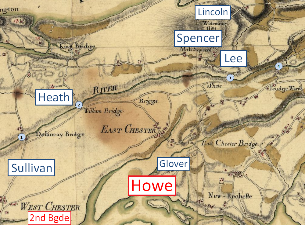
This map shows the distribution of Washington’s army units in Westchester County on October 18, 1776 (click to enlarge). The placement of the units on this map is inexact. North is up at the upper-right corner of the map. A part of the Hudson is at the top of the map, and a part of Long Island Sound is at the bottom.
While Howe’s army landed at Pell’s Point, the 2nd and 6th British brigades conducted a feint on Throg’s Neck. (The 2nd brigade is shown near the head of Westchester Creek; the 6th brigade was in an off-map location near the bridge at extreme lower left). The divisions of William Heath and John Sullivan watched over the British on Throg’s Neck and defended the shoreline between Throg’s Neck and Manhattan (off map, at left). The crossings of the Bronx River are marked by the numbers 1-4. One part of Charles Lee’s division guarded these crossings, while another (John Glover’s brigade) contested the British advance from Pell’s Point. During the day, Joseph Spencer’s division marched from Kingsbridge (upper left) to Valentine’s Hill (upper right).
Footnote: The sentries were probably a detachment of militia. Militia units from Massachusetts, Connecticut, and New Hampshire were placed in various locations along the shore of Long Island Sound and Hudson’s River to watch the movements of the British navy, safeguard caches of supplies, and keep key points out of the hands of the Loyalists. The detachments were not expected to stop a major drive by the British army. New York militiaman Benjamin Bogardus later wrote, “The orders came from [Major] General [Charles] Lee, for all the guard along the shore to draw back and let them [the British] land”.
No comments:
Post a Comment